
The construction of a train station and its surrounding open spaces in our neighbourhood was the outcome of extensive manoeuvring by the Victorian Railway, culminating in a number of options going up to Parliament for consideration and funding in 1887.

On 9 December, 1887 The Argus published the plan pictured right, with the following analysis:
"The above plan shows the extension to the Rival Direct Routes (particulars and relative cost of which were given in our issue of Wednesday, 7th Inst), and also the Junction of the Existing and Proposed Lines at Union street, Northcote. The Scheme for the Fitzroy and Whittlesea line (the contract for which was recently let, and the works now in progress of construction) provides for an extensive station at Union street on the St. George's Park Estate, the area of land acquired by the Railway department for that purpose embracing a width of 264ft., extending from Union street to Charles street and at the time the land was taken over by the department some surprise was expressed at the large area to be utilised for station purposes. It is now, however, evident that the Commissioners foresaw the absolute necessity for providing for the loop lines to connect both the Outer Circle Line and the Alphington and Heidelberg Line with the Fitzroy or Collingwood Line at this point, and last week the Commissioners completed arrangements with the proprietors of the Fitzroy Junction Estate (the adjoining block between Union street and Westgarth street) to acquire a still wider strip in order to provide for the loop lines referred to. The question as to which direct route is to be adopted having yet to be decided by Parliament, the Railway Commissioners have exercised a wise discretion in thus securing in the meantime the land necessary to provide for the Junction of the important lines above referred to [...] In settling for the purchase of this land, provision was wisely made by the Commissioners for the erection of a footbridge (in connection with the Railway Bridge across the Merri Creek) opposite the lower end of Westgarth street, which will give ready and easy access to and from the Northcote Junction Station."
Amazing to note that the iron footbridge that takes us across the Merri Creek between Northcote and North Fitzroy is original! Built in the 19th century along with the rail bridge that supports it.
The purchase of a larger-than-necessary parcel of land by the Railway department explains why we have so much wonderful open space around the Merri Station to share, rehabilitate and enjoy today. Obviously, the rivalry between the Fitzroy and Collingwood lines was shortly settled, with works funded to connect Clifton Hill with the stations in the City of Melbourne via Richmond. The 1890s Depression and eventual decline of both the Inner and Outer Circle railways definitively closed the chapter on the "Grand Junction Central Station" concept so triumphantly marketed by the real estate agents of the day:
 |
| This 1885 land sale advertisement for the "St George's Park, Fitzroy Junction" estate places the "Grand Junction Central Railway Station" over in North Fitzroy, beside St George's Rd. |
.bmp) |
| By 1887 the proposed location of the super-station had been settled, with the Railway department buying up land from the owners of the Fitzroy Junction Estate for this purpose. Note the footbridge! |
 |
| Melbourne Metropolitan Board of Works - note the grand ambitions of "Davies St" to the south, evidently making a play for the Merri Creek. It seems the original intention of planners was for "Davies St" (now a curious dogleg in Sth Park St terminating at Merri Parade) to continue across the Creek along the rail reserve and meet up in North Fitzroy with - you guessed it - Park St. Westgarth St is also shown on all early maps as connecting to Holden St (aka "Government Rd") across the Creek via a bridge that was never built - again, chalk it up to the 1890s Depression. |
Eventually the Station was built and named, somewhat sensibly, "Northcote." It opened on 8 October, 1889, with the rail line bisecting the "St George's Park Estate" into east and west. For many years the level crossing at Charles Street passed straight across the line, creating a direct carriageway from High Street to St George's Rd, perhaps explaining the sprinkling of old shop fronts on the decidedly residential east side. With the increasing population and addition of new railway stations further north, the station was renamed "Merri" in 1906 with the next station to the north now attaining the name "Northcote."
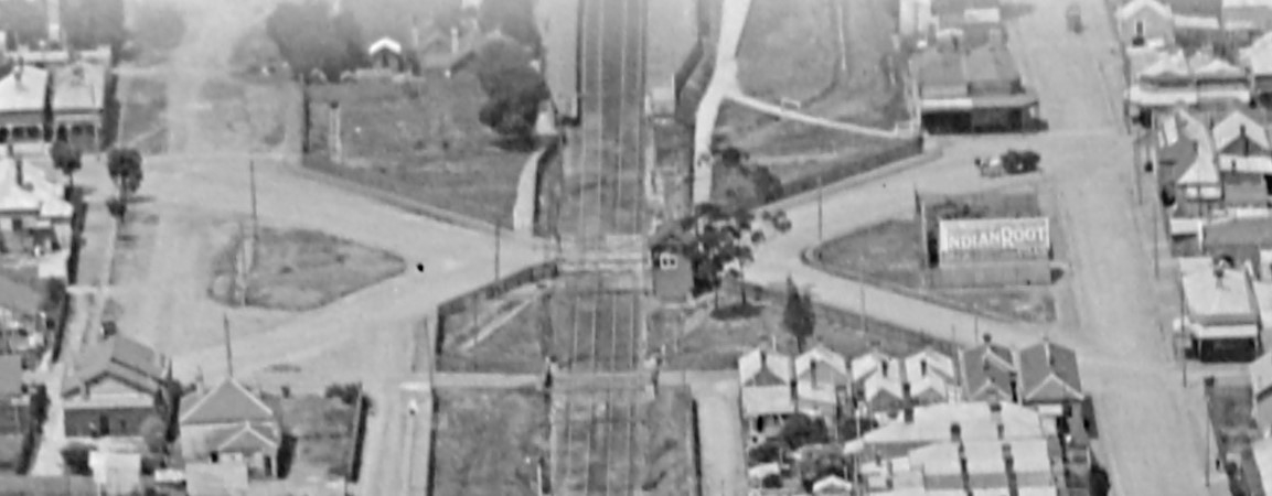 |
| The Merri Station rail crossing in 1928, joining Charles and Clarke Streets across what is now Merri Common (top left) and Caddaye's Corner (bottom right, where the "Indian Root" sign stands. The historical roads are now incorporated to the parkland, but the titles remain with the City of Darebin, contributing to the complexity of statutory ownership on Merri Common. This is a detail from an aerial photograph of Northcote (from the north, looking south) by Charles Pratt, available from the State Library of Victoria. |
Merri Station was rebuilt in 1910 to accommodate the increased rail patronage from the area, which is likely when the level crossing was also remodelled to connect Charles St with Clarke St via a criss-cross intersection across the rail line - creating the old Caddaye's Corner on the west side and carving up what is currently a unified Merri Common on the east. It would have been a traffic nightmare.
 |
This was from The Argus' popular lifestyle section devoted to lovers of English Cricketers, Rare Java Parrots and Northcote Level Crossings
Originally the gates at the level crossing were hand operated, but a single gate operated from the nearby signal box was installed in 1924 after "several serious traffic accidents." Check out the photo of the signal box (if you can).
More later! Hopefully.